GPS Coordinates and Navigation in Iceland
A recent search & rescue mission brought up an interesting topic that I thought would be worth writing about in more detail. Part of the difficulty in this mission was to locate the party in distress due to the inaccuracy / miscommunication of their position, despite them carrying a GPS device which should provide a location accuracy of about 5-10 meters in average conditions – more than good enough to find anybody even in a fairly severe snow storm.
When communicating a position on the globe, there are a multitude of options that all have their advantages and drawbacks – but for the precision required for everyday use the simple specification of degrees latitude and longitude is entirely sufficient and the most common method. Latitude is a value between 0° and 90° north or south, and longitude is between 0° and 180° east or west, with 0° latitude being the equator and 0° longitude the prime meridian at Greenwich. South and west values are often specified as negative values, but not always.

Degrees, Minutes, Seconds, and decimal points
While this has become the de facto standard for communicating global positions, there are different ways in which those angles can be specified. Similar to how hours can be split further up into minutes and seconds, latitude and longitude are commonly subdivided following the same rules (except that one minute is not 1/60 of an hour, but 1/60 of a degree). To further complicate matters, there are actually three common methods: decimal degrees (often abbreviated DD), degrees / decimal minutes (DDM), or degrees / minutes / seconds (DMS). So while the degrees value is always the same, the fractional part of a degree is either written as a decimal value (“Decimal Degrees”: 17.48°) or in 1/60ths (17°28.8'), and since the minutes value is also often fractional the same applies – we can either just write it out as a decimal too (as we did before) or do the same conversion again to arrive at seconds (17°28'48").
Here are three scales showing the same values in each of these systems:
Generally speaking, they are often written down as dd.ddddd° , dd°mm.mmm', or dd°mm'ss.s" respectively (with d, m, and s representing digits of the degree, minute, or second values, and the °, ‘ and ” symbols to differentiate them). This gives approximately the same precision in each of the representations and is accurate to about three meters, similar to the actual positional accuracy achievable with consumer grade GPS devices. It is also common to omit the least significant digit if less precisison is required / available (for example, dd°mm'ss" or dd°mm.mm').
Most notably these representations all have the exact same number of digits and are potentially close enough in value that it may not be immediately obvious which representation was chosen. Therefore when communicating coordinates it is extremely important to be clear about which of these systems are being used, to ensure that the receiving party interprets them correctly.
In Iceland, it is standard practice to use DDM (degrees and decimal minutes) to specify coordinates, both within the search & rescue and other emergency response teams and the Icelandic Coast Guard. If the coordinates are given up in a different system by third parties, they are generally converted to DDM before being communicated to the responding SAR teams.
With a refresher of those fundamentals out of the way, we are now ready to look at the situation on Grímsfjall in detail.
Misreading Coordinates
The notification we received was, roughly translated:
(more or less direct translation of the alert message I received on my phone)
Priority 2-Injured person - 64°24,400' N 17°15,150 W, near hut/shelter - [...] - mountain rescue, injured ski mountaineer 1km east of the Grímsvatn hut. [...]
If we place the specified location on a map, it all checks out:
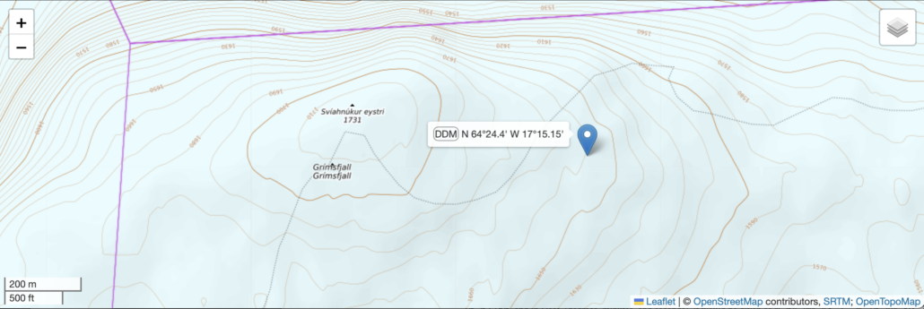
The location is indeed about 1km more or less straight east from the hut that ski mountaineers often visit during their traverse, it is roughly on the route that people take off the mountain (though a bit too far north, there is a large moulin further east that needs to be avoided by diverting south – but still plausible). So no reason to doubt any of the information.
Except when our snowmobile team arrived, there was nobody to be found at the specified location. We know GPS positions are not always exact, and visibility was severely limited to the point that the group could easily in fact be nearby this location but simply invisible, so they were carefully extending their search radius as far as it was feasible without too much risk – but to no avail.
It became increasingly clear that something must be off, and eventually the mistake discovered: the position had in fact been given in DMS, and was thus 64°24'40" N 17°15'15" W (and not 64°24,400' N 17°15,150 W). But somewhere between their communication and the information the search & rescue teams had received, it had been written as DDM. We do not know if it was a language problem or other miscommunication between the caller and the emergency hotline, or a mistake that was made upon entering the call into the system and notifying SAR.
Here is where the DMS position places us:
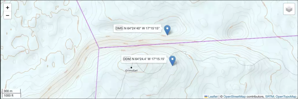
Now, in many ways this location makes more sense – on the initial location it is somewhat difficult to imagine how a person may sustain severe injuries while a 200m fall would definitely produce those, but in others it doesn’t: it is to the northeast of the hut (not east, as communicated), and the near vertical slopes / cornices to the north of the mountain are nowhere near the regular routes up / down the mountain.
But for the ongoing rescue, the new location also produced some other issues. The concentric circular elevation lines in the map already hint at the instability of the glacier in the area, which is sitting on top of a rather active volcano and made the approach and rescue a much more difficult and potentially hazardous operation than initially anticipated. From the original position, it would have been quite easy for the snowmobile teams to transport the party back into the shelter of the mountain hut and then await evacuation in a closed vehicle, but the new position required careful planning and even more careful progress using snowmobiles, heavily modified superjeeps, and a snow cat. A rope team scouted the very last stretch on foot before allowing vehicles to drive into the potentially unstable terrain.
Ultimately the rescue was a complete success, and in retrospect not too much time was lost overall due to the miscommunication – the slow moving but very gentle snow cat that was used to transport the injured person was still on its way and could not have reached the incident location much sooner anyway (we also decided not to move her before everything was in place, so that she could be transported from the relative shelter of the group’s tent to the snow cat in one go). An earlier assessment of the injured person and the other members of her group would have been desirable but fortunately in this case it did not change the overall outcome.
However, it remains a good opportunity to look at what went wrong in more detail, and how a similar situation can be avoided or identified more quickly in the future.
Plausibility
Of course, some of the possible mixups of latitude/longitude figures could be easily identified. If the digits would result in, say, the minutes or seconds value to be 60 or more, that would be easy to catch as invalid (since the degrees or seconds values should never be more than 59,9999…). And some resultant locations are very obviously so far away from the true position that they are easy to exclude (if somebody is in trouble on a mountain, they clearly aren’t going to be in the middle of the ocean). It is the near misses that are dangerous.
Let’s take the example of above and see what the options are for each of the “wrong” combinations and how far off they would be. For simplicity we will just look at the latitude in the table below:
| Actual Coordinates (position converted between DMS/DDM/DD) | 64°24.67' | 64°24'40" | 64,4111° |
| .. misread as Degrees / Decimal Minutes | ( correct ) | 64°24,40' | 64°41,11' |
| … misread as Degrees / Minutes / Seconds | 64°24'67"(implausible) | ( correct ) | 64°41'11" |
| … misread as Decimal Degrees | 64,2467° | 64,2440° | ( correct ) |
So in addition to the actual correct position, there are six possible misreadings, depending on which combination of coordinate systems were used vs. expected.
It may be worth pointing out that while that 64°24'67" value is technically incorrect, it is equivalent to 64°25'07" (just like 90 minutes and 1 hour 30 minutes mean the same thing), and many mapping tools will interpret it as such. I used the PROJ tools of the OSGeo project to make these calculations, but for example Garmin’s BaseCamp also happily accepts the “wrong” value. So while it is an indication to the watchful eye that something may be amiss, we can’t necessarily rely on the tools to tell us so, as they will not reject it as a malformed value.
We can then calculate how far off they are (now using both latitude and longitude, of course):
| Degrees / Decimal Minutes | Degrees / Minutes / Seconds | Decimal Degrees | |
| .. misread as Degrees / Decimal Minutes | ( correct ) | 500m | 31.6 km |
| … misread as Degrees / Minutes / Seconds | 830m | ( correct ) | 33.6 km |
| … misread as Decimal Degrees | 18.9 km | 18.7 km | ( correct ) |
You can clearly see how the two closer misreadings (bold above) are actually still rather plausible given a brief description of the approximate location, whereas the other four, more distant points would most likely be immediately ruled out.
More generally speaking, we can also make an estimate of the possible range of those misreadings. A latitude of 64°00'00" is exactly equal to 64°00.00' or 64.0000°, so there is no difference there at all. But what is the largest possible deviation? If we consider, for example, 63°59'59", then misreading this as 63.5959° is about 0.4° off – a 45km difference! Similarly, 63°59'59" and 63°59.59' are about 0.4′ apart, which is still about 730 meters. Differences in longitude vary with latitude and are less (at 64° latitude, about 20km and 320 meters respectively). If we allow malformed readings, the possible error increases even further to 74km and 1230m (for 64.9999°, 64°99.99', and 64°99'99").
Fortunately, by looking at the above table it is easy to see that no matter how the point was specified, one in three choices will necessarily give the right answer. So we only really need to consider three possible locations and can be assured that the correct value will be one of them.
I have made an interactive tool that allows you to do just that – enter coordinates either as an “anonymous” stream of digits or in any of the three standards (DMS, DDM, or DD), and it shows where all these possible points end up on the map. It also automatically converts each of these interpretations to the respective other coordinate systems, which may be useful. You can find it at https://tools.stepman.is/gps.
Bottom Line
So, what does all of this mean for us?
Clearly one should always use the tools and methods one is most familiar with – this will keep you from making mistakes in particularly stressful situations and an emergency is not the right time and place to start changing the settings on your GPS to what you believe the other side wants to hear. No matter which system you end up using for your location, always explicitly specify it to the receiving party, and ensure they read it back to you correctly. And always add additional information that specifies the landscape around you.
“Our location is in Degrees and Decimal Minutes: North Six Four Degrees Two Four Point Six Six Seven Minutes, West One Seven Degrees One Five Point Two Five Minutes. We are at the bottom of a very steep slope at an altitude of about 1450m. The terrain seems to become much flatter to the north of us.”
For serious endeavours, PLBs or satellite messenger devices like Spot or InReach add the additional safety of automatically transmitting your precise location to the rescue center with any emergency transmission, so there is no need to worry about coordinate systems at all. However, any additional information you can pass on (such as “we are at the very bottom of the steep slope to our south, and the terrain appears to be much flatter to our north“) is still very valuable for planning and executing your rescue, so please do communicate these observations if you can.
Stay safe!