
About Sólheimajökull
In recent days I had heard multiple remarks about how access to Sólheimajökull was getting increasingly precarious, and a number of people in the guide community asked me of my opinion. So when I had a day off earlier this week and the weather was promising, I figured why not go and have a look?
And, if I am going already, why not bring my drone and map out the area in question…
The result was a high resolution map (orthophoto at 3cm resolution, digital elevation at 10cm resolution) as well as a photogrammetric 3D reconstruction consisting of 492 million points. Some artifacts remain in the resulting model due to reflections in open water surfaces and lack of ground control points, but for the purpose at hand I decided the data would be more than good enough.
I should add that since I am relatively infrequently on this glacier and not part of any conversations between the operators, I am obviously not fully informed of any efforts that may already be in place. So some of what I am writing is likely to be redundant, or based on inaccurate or outdated information.
Nevertheless, I am writing this in the hope that some of these thoughts are useful, and also to showcase how high resolution remote sensing tools and GLACIS, the system I have been building to assist the operators in Vatnajökull National Park, could be a useful tool for shared situational awareness across operator boundaries.
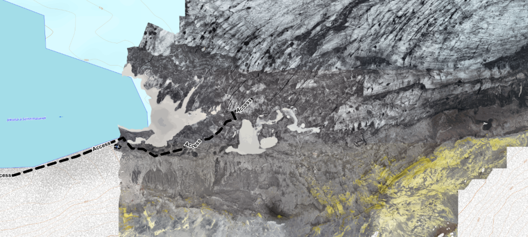
Rockfall / Landslide Hazard
The rockfall hazard on the hiking trail is well known, and every time I go to Sólheimajökull (which, admittedly, is not very often) it certainly motivates me to not spend too much time in the exposed area.
Rockfall is generally influenced by seasonality (highest risk in the spring, then gradually diminishing in autumn towards winter), but I have also heard of – but not personally seen – indications for larger scale movements in the surrounding mountain similar to the fractures observed on Svínafell in Öræfi which may not necessarily follow the same patterns.
I am a strong believer in good decisions coming from good information, and I believe it would make sense to implement a structured approach to monitor and document any larger scale movements or rockfall. Ideally, a remote sensing system such as a permanently installed TLS might be installed but other, more localized methods (such as measuring the deformation of observed fractures, and repeated high-resolution photogrammetry) could be implemented at a fairly modest cost. This has in fact been done before, although with a focus on glaciology rather than rockfall monitoring.
This also matches very well with my efforts to build a system to track very similar changes in ice caves, and in fact the new iteration of GLACIS was designed with this broader scope in mind.
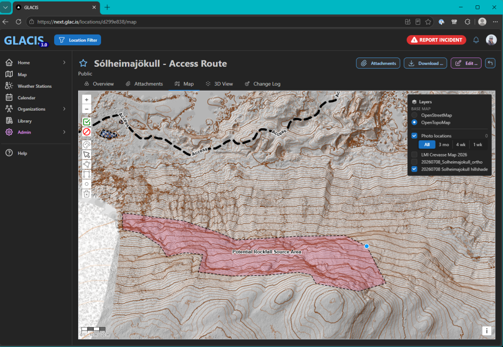
In addition to the present orthophoto and topographic maps, it would be relatively easy to add additional information such as estimated rockfall shadows calculated by geophysicists.
Besides monitoring and documentation, the only other mitigation strategy that appears available is avoidance, ie. finding a route that circumvents rockfall hazards as much as possible and takes the fastest possible path where exposure is obligatory.
Dead Ice
Once past the rockfall, the access trail follows the foot of the mountain and over a small tongue onto the glacier proper. While apparently rocky / sandy terrain, it is quite evident that the path in fact leads over dead ice. This raises the question of how well supported this terrain is, since it is in fact the margin of a glacier lake and new sink holes are known to have formed quite rapidly in the past.
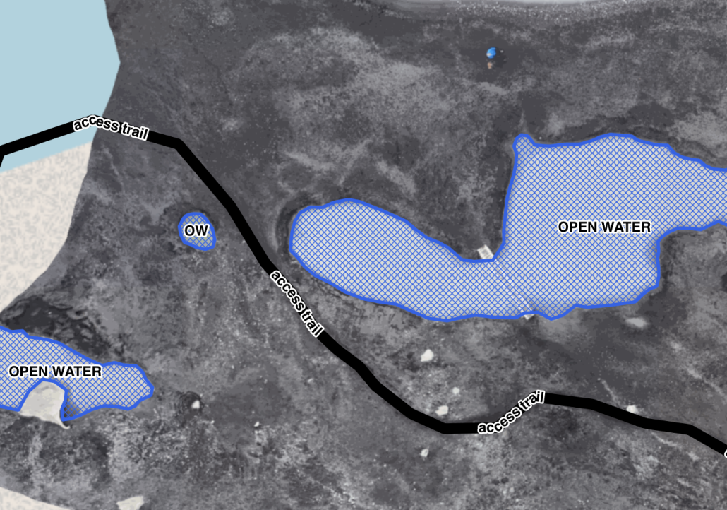
The main risk here is of course a person venturing over unstable ground, falling into open water of unknown depth and (in the worst case) drowning. While unlikely, it feels prudent for outdoor professionals in the area to be prepared for this eventuality – not necessarily with a casualty from their own group, but because the area is also accessed by private individuals who may be unaware of the risks (and thus more likely to encounter the consequences).
In addition, monitoring and mapping these development may give some insight into how the subsurface water flows and ice structures are evolving, and where additional weakness may be encountered. In particular, one of the most pressing questions for me is how deep those sinkholes are1.
Fast Ice
The final step before accessing the glacier proper leads over an isthmus-like ice bridge, bounded by open water on both sides. It is difficult to establish if this is shore-fast ice (floating but anchored to the shoreline), or in fact grounded (sitting on the lake bed).
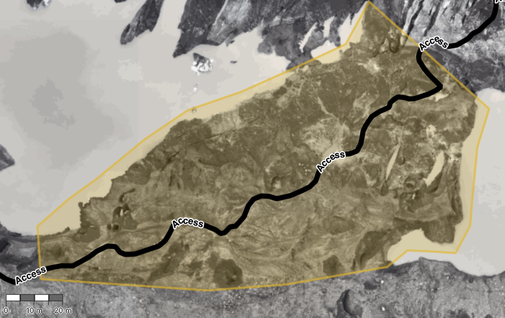
The glacier flows generally in a right-to-left direction in this image, at about 0.1m/day. I would expect this to further destabilize the ice bridge at its narrowest part (top right). With the expected mass loss during the summer months, I would expect this path to become unstable very rapidly. Sections in this area already show very strong evidence for being undercut in close proximity to the current path.
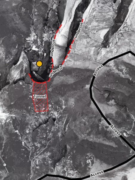
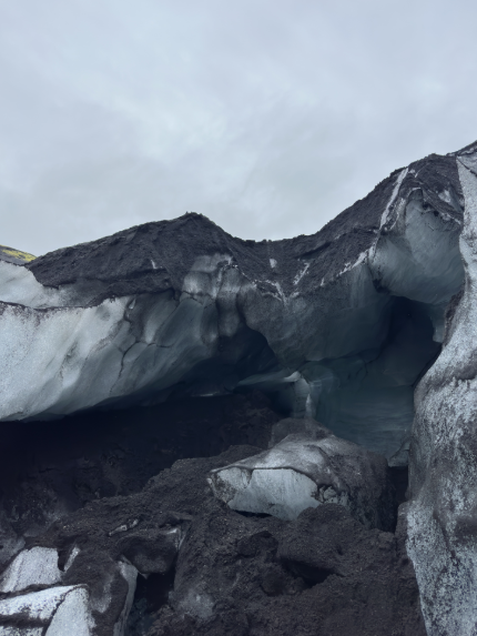
Overall, it is quite evident that access to the glacier proper via this ice bridge will very soon be impracticable. Making any sort of prediction about the time line is almost guaranteed to be wrong, but it feels to me that this is a matter of a few weeks, if not days. Given the evidence we see for unstable layering and weaknesses near the choke point, it is at least conceivable that this route could become impassable while people are in fact on the glacier, or even worse result in a (localized) collapse under a group’s combined weight.
For a longer time frame, I would be very interested in creating a detailed 3D capture of the ice bridge (possibly using a combination of terrestrial laser scanning and photogrammetry), but assuming that this access point may likely no longer be viable within 2-3 weeks it may be of questionable benefit2.
I believe at least some operators are already investigating alternative access routes that leads to the glacier via more solid ground.
What Now?
This is of course the most difficult question of all. Much of what can realistically be accomplished depends very much on the type of operation – a single person owner-operator clearly has access to much more limited resources than a corporation with hundreds of staff, but also enjoys significantly more flexibility when it comes to operational changes that may be very difficult to implement by a larger operation where shifts in timing or resource use can be very complex to manage.
Individual vs. Collective Risk Taking
With a heavily visited, public access location such as Sólheimajökull it is important to consider not only the risks as they apply to a single individual or isolated operator, but to also evaluate them as they apply to the entirety of visitors.
Statistically, the incidence or likelihood of any singular event such as rockfall, or sink hole collapse is perhaps not very high, and thus the individual risk may be low. But given the steady stream of visitors during the summer months – both on their own and on guided tours – the area in question is almost constantly occupied and consequently the overall likelihood of somebody being in the wrong place at the wrong time is significantly higher. So the collective risk must be considered to be quite substantial.
This situation is made even more precarious because the population of visitors in the area is a mixture of professionally guided tours of different kinds as well as private individuals on their own. It must be assumed that the vast majority of the latter group would have little to no awareness of the specific risks present, and modest physical abilities at best.
The Guided Tour Conundrum
While the decision making of such private individuals is not under control of any tour operator or guide, the opposite is not quite the case either. Guided tours carry the implicit guarantee of being as safe as humanly possible, and therefore the path a guide chooses for their customers is likely to be perceived as the safest possible route and likely to be followed by private people as well – who are quite possibly unaware of the particular hazards they may encounter on the way nonetheless, and ill equipped to deal with them. In addition, paying customers will (more or less blindly) accept the guide’s judgment of the access hike being ‘safe enough’ and misjudge the element of risk that remains despite the guide’s best efforts to be much lower (ie. negligible) than it might actually be.
Information signage (which is already present on Sólheimajökull) is a helpful tool, but the question remains of whether this is sufficient and how for example any works to facilitate quicker movement through rockfall exposure may in fact motivate more private visitors to venture into the space. Which might simultaneously reduce the risk to each individual (shorter exposure time), but increase the risk to the collective (more people present overall).
Public policy makers will need to consider these effects carefully, especially since we are dealing with low-probability but high-consequence scenarios.
Immediate Actions and Mid-/Long-Term Strategies
Nonetheless, I believe at least in part the sections above already give a direction which should be taken, with some aspects warranting immediate or very short term measures while others may have a bit more time to develop further.
I do not feel like I have any satisfying answers to which immediate actions should be taken.
Clearly the collective time spent in any area exposed to rockfall should be reduced as much as possible, ideally down to zero by finding an alternative route that entirely circumvents the exposed area. Physically restricting access to the general public while keeping it open for commerical operations is a tricky subject and I have some doubt that this – or closing access outright, including for all operations – would be feasible or justifiable.
Similarly, the exposure to open water might be limited by good route finding. But since one would like to stay away from the rockfall runout as much as possible, this could be a difficult balance to strike. If accidental cold water immersion cannot be completely ruled out, the next best thing is of course to focus on mitigating its consequences by being ready for an effective rescue and care.
Perhaps the most pressing issue is the ice bridge, with its layered and possibly unstable ice structure bounded by open water and very limited flexibility for route finding for low- to modest-ability customers. Dilligent monitoring for futher changes and a low threshold for further deterioration feel important, as well as an immediate formulation of alternative access – and even more importantly escape – routes. Guides should be ready for rapidly developing changes and complex rescue scenarios.
Establishing monitoring and documenting changes to the ice bridge leads directly to the other aspect – apart from addressing the most pressing issues at hand, what could the strategy be to ensure continued and safe access to Sólheimajökull? And which additional information may be useful and should be collected to make the best possible decisions?
For me, collecting more data about rockfall is perhaps the most pressing point because it is a low-incidence but high-consequence hazard. Monitoring the fissure and documenting rockfall events feel like a logical next step, and of course this would be done in collaboration with geophysicists who have both the tools and expertise to interpret the results.
Establishing a rough depth profile of the nearshore area of the glacier lake and potential sinkhole depths would help both gage the consequences of an incident involving cold water immersion (do people get wet but can walk out? is there a risk of drowning?), and gain a better understanding of how the ice bridge may develop in the future (is it, and the attached glacier, grounded or floating?).
It is also evident that the ice bridge is a very temporary access point. Continuing the access hike along the base of the mountain appears feasible, but a rough estimate indicates it might add another 3-400m of walking each way, before reaching the ice. This could very well prove challenging, especially for low-ability customers and/or the scope of short-duration tours.
Shared Situational Awareness
There is no doubt that the primary expertise and wealth of observations lies with the operators and their guides who are in the area on a daily basis. My infrequent visits and incomplete knowledge of the situation is obviously no match for them, and it would be outright ridiculous to claim otherwise.
Nevertheless, it is one of the main criteria for being a good guide to constantly evaluate and form an opinion on the environment they work in. This might be based on incomplete knowledge, wrong assumptions, and influenced by all sorts of factors from personal experience to customer profile, but it is the foundation of all decision making.
The true strength of those individual opinions, even if they are inevitably flawed in some way and incomplete, arises when they are shared, compared and combined with others’ perceptions until a coherent and much more thorough picture emerges.
Similarly, public policy makers, emergency responders, operations managers and other individuals can contribute to and benefit from this process and its outcomes.
To achieve this, it is important to create an environment where all stakeholders are willing and able to share information – ideally moderated by a person who is unequivocally accepted by all participants as being objective and competent – and by having access to the necessary tools to collect, evaluate, and share any relevant data.
This is exactly the process we have been developing within the Vatnajökull National Park over the last two years, by refining the way in which Fagráð and the Assessment Group – representatives from all participating companies – worked together and discussed their observations and concerns in a regular and proactive fashion, and GLACIS was built – and continues to be developed – as a tool to assist and document this process and provide a common operational picture.
As I outlined in my previous post, I like to believe that we have come quite a long way with this process, and perhaps it is time to look beyond Vatnajökull and open a discussion about whether a similar approach may not be useful elsewere.
- In retrospect, it would not have been a bad idea to bring a drysuit… ↩︎
- Except that it poses an interesting challenge and would help refine my data acquisition workflow ↩︎
About the Author
Stephan Mantler has served as chairman of Fagráð, the professional council for safety in glacier hikes and ice cave tours within Vatnajökull National Park, since 2024. Before pursuing a career as an outdoor professional, he earned a Ph.D. in computer science with a focus on the management and interactive visualization of large-scale geospatial data. He is the creator of GLACIS, a collaborative platform for glacier and ice cave risk assessments, condition reports, and operational situational awareness. Stephan currently serves on the board of AIMG and is an instructor for AIMG ice cave courses, a Rescue 3 Ice Field Safety and Ice Rescue Technician Instructor, and an ICE-SAR mountain rescue instructor.

