In a recent discussion, the topic came up of how to make the transition of having a written Risk Management Plan and other safety documentation, and actually putting it into practice in larger organisations. Here’s an analogy that came to my mind.
Consider encouraging children to eat more vegetables.
Saying “You must eat your greens, because they are healthy and good for you!” might have the desired result, but not because of some inner motivation and more for wanting to avoid the consequences of not doing so. But the moment nobody is watching, it’s all french fries and chocolate milkshake again…
In other words, it doesn’t really work.
What does work is preparing the vegetables nicely and with care, so they actually taste nice and are a joy to eat, to the point that the kids come back for seconds.
It is essentially the same with safety documentation.
A poorly written document, that reads like overcooked, bland string beans with no flavor, essentially signals to the reader that the author did not care enough to prepare it well. And so the reader won’t care about the content either. Sure, people will read the documentation because it is requried, but not because they want to or see how it provides them with any useful information.
They won’t identify with the message.
Instead, documentation that is deemed so important we want staff members to sign off on having read it, must be a joy to read. It needs to show respect to the reader by giving them the information they need in a well structured, easily understood way. It should be accessible, and so useful that people will want to keep it with them for quick reference in the field.
Writing good documentation is not easy. It takes time, experience, and expertise. None of this comes for free, and it may be advisable to look for external advice.
But it is worth the effort, because it sets the tone for how we approach safety. It shows we care.
And so our readers will care, and strive to put our words into their practice.
https://www.stepman.is/wp-content/uploads/2023/10/WP_Logo_Black.png00stephttps://www.stepman.is/wp-content/uploads/2023/10/WP_Logo_Black.pngstep2026-08-30 07:06:222026-08-30 07:32:12Eat Your (Safety) Greens!
In recent days I had heard multiple remarks about how access to Sólheimajökull was getting increasingly precarious, and a number of people in the guide community asked me of my opinion. So when I had a day off earlier this week and the weather was promising, I figured why not go and have a look?
And, if I am going already, why not bring my drone and map out the area in question…
The result was a high resolution map (orthophoto at 3cm resolution, digital elevation at 10cm resolution) as well as a photogrammetric 3D reconstruction consisting of 492 million points. Some artifacts remain in the resulting model due to reflections in open water surfaces and lack of ground control points, but for the purpose at hand I decided the data would be more than good enough.
I should add that since I am relatively infrequently on this glacier and not part of any conversations between the operators, I am obviously not fully informed of any efforts that may already be in place. So some of what I am writing is likely to be redundant, or based on inaccurate or outdated information.
Nevertheless, I am writing this in the hope that some of these thoughts are useful, and also to showcase how high resolution remote sensing tools and GLACIS, the system I have been building to assist the operators in Vatnajökull National Park, could be a useful tool for shared situational awareness across operator boundaries.
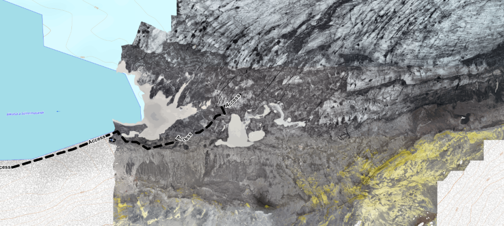
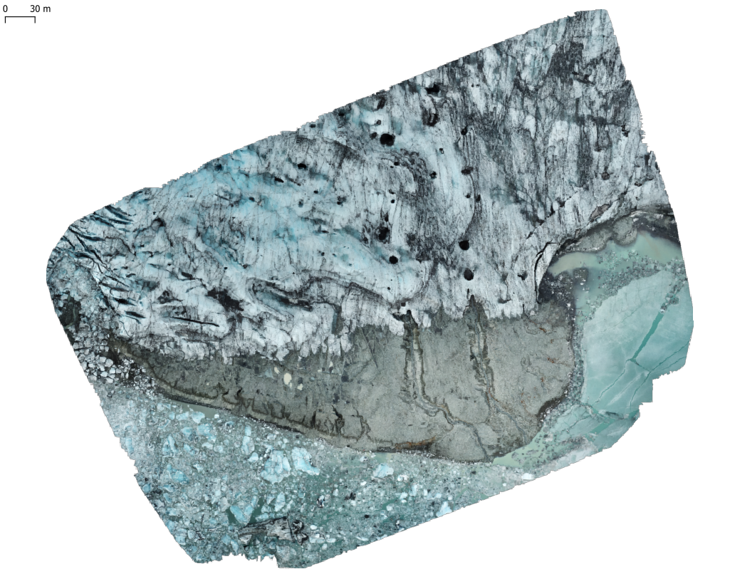
Orthophoto of the southern section of the terminus, with the approximate access route marked. The current access trail leads from the parking area (off to the bottom left edge of the image) along the lakefront, and over the land bridge onto the glacier proper.
Rockfall / Landslide Hazard
The rockfall hazard on the hiking trail is well known, and every time I go to Sólheimajökull (which, admittedly, is not very often) it certainly motivates me to not spend too much time in the exposed area.
Rockfall is generally influenced by seasonality (highest risk in the spring, then gradually diminishing in autumn towards winter), but I have also heard of – but not personally seen – indications for larger scale movements in the surrounding mountain similar to the fractures observed on Svínafell in Öræfi which may not necessarily follow the same patterns.
I am a strong believer in good decisions coming from good information, and I believe it would make sense to implement a structured approach to monitor and document any larger scale movements or rockfall. Ideally, a remote sensing system such as a permanently installed TLS might be installed but other, more localized methods (such as measuring the deformation of observed fractures, and repeated high-resolution photogrammetry) could be implemented at a fairly modest cost. This has in fact been done before, although with a focus on glaciology rather than rockfall monitoring.
This also matches very well with my efforts to build a system to track very similar changes in ice caves, and in fact the new iteration of GLACIS was designed with this broader scope in mind.
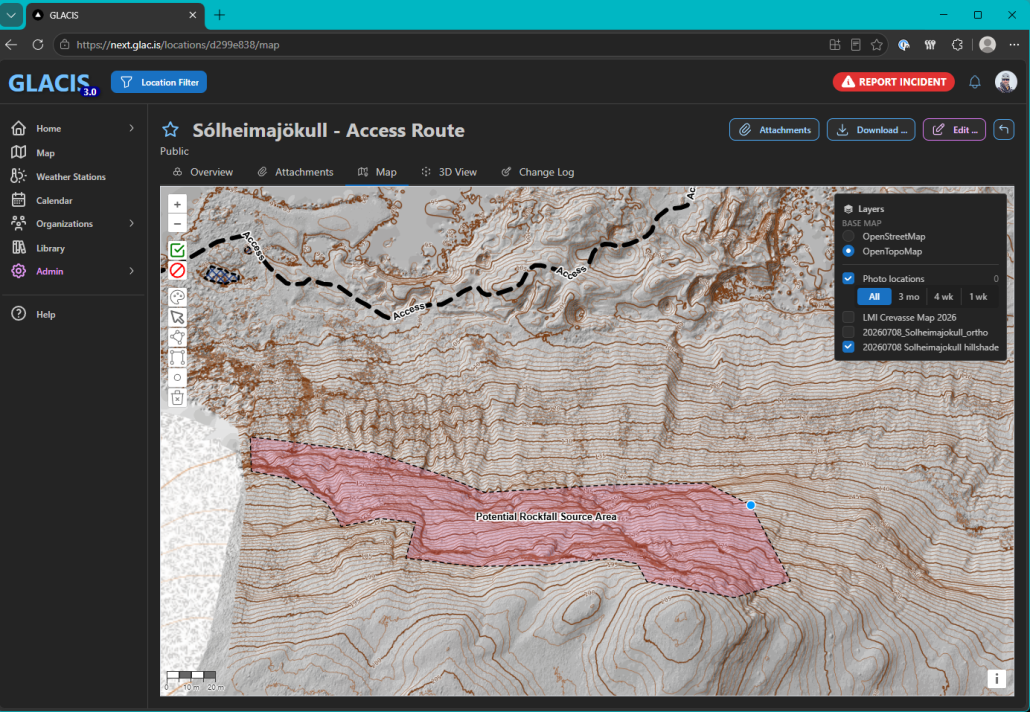
GLACIS now supports drawing annotations directly on the map display and location-specific overlays. Here, I added a high resolution topographic map, with contour lines drawn at 1m intervals and marked out the most obvious area for triggering potential rockfall, based on where contours showed near vertical or overhanging terrain.
In addition to the present orthophoto and topographic maps, it would be relatively easy to add additional information such as estimated rockfall shadows calculated by geophysicists.
Besides monitoring and documentation, the only other mitigation strategy that appears available is avoidance, ie. finding a route that circumvents rockfall hazards as much as possible and takes the fastest possible path where exposure is obligatory.
Dead Ice
Once past the rockfall, the access trail follows the foot of the mountain and over a small tongue onto the glacier proper. While apparently rocky / sandy terrain, it is quite evident that the path in fact leads over dead ice. This raises the question of how well supported this terrain is, since it is in fact the margin of a glacier lake and new sink holes are known to have formed quite rapidly in the past.
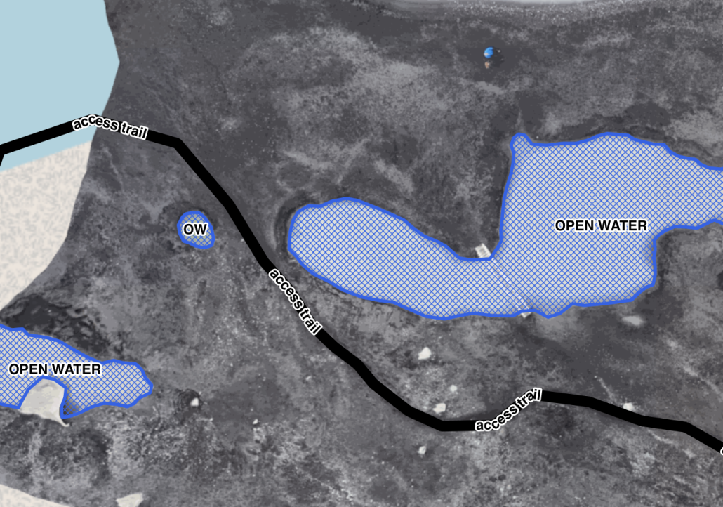
Sinkholes and open water are encroaching on the access trail. Note the bridge across the open water on the right.
The main risk here is of course a person venturing over unstable ground, falling into open water of unknown depth and (in the worst case) drowning. While unlikely, it feels prudent for outdoor professionals in the area to be prepared for this eventuality – not necessarily with a casualty from their own group, but because the area is also accessed by private individuals who may be unaware of the risks (and thus more likely to encounter the consequences).
In addition, monitoring and mapping these development may give some insight into how the subsurface water flows and ice structures are evolving, and where additional weakness may be encountered. In particular, one of the most pressing questions for me is how deep those sinkholes are1.
Fast Ice
The final step before accessing the glacier proper leads over an isthmus-like ice bridge, bounded by open water on both sides. It is difficult to establish if this is shore-fast ice (floating but anchored to the shoreline), or in fact grounded (sitting on the lake bed).
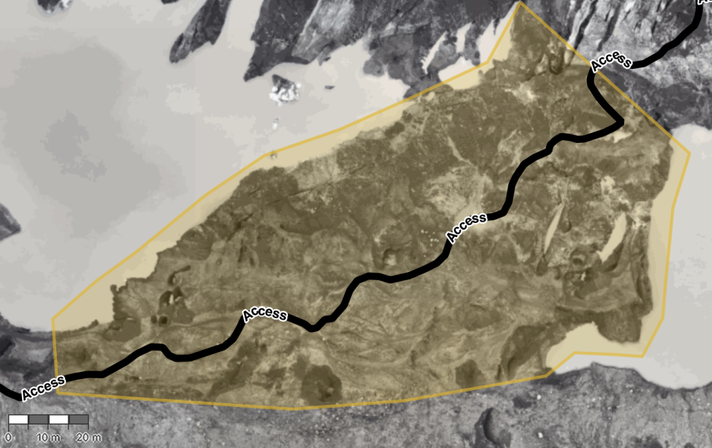
The “ice bridge” currently being used as the access path, arriving from the bottom left of the image and reaching the glacier at the top right.
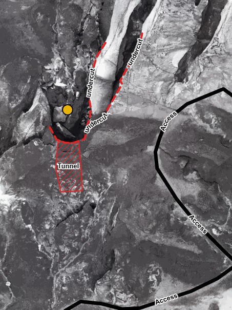
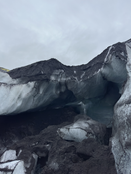
The glacier flows generally in a right-to-left direction in this image, at about 0.1m/day. I would expect this to further destabilize the ice bridge at its narrowest part (top right). With the expected mass loss during the summer months, I would expect this path to become unstable very rapidly. Sections in this area already show very strong evidence for being undercut in close proximity to the current path.
Plan view of undercut and tunnel close the path. Photo on the right was taken at the yellow marker.Deeply undercut and destabilized layering and tunnel formation close to the access path
Overall, it is quite evident that access to the glacier proper via this ice bridge will very soon be impracticable. Making any sort of prediction about the time line is almost guaranteed to be wrong, but it feels to me that this is a matter of a few weeks, if not days. Given the evidence we see for unstable layering and weaknesses near the choke point, it is at least conceivable that this route could become impassable while people are in fact on the glacier, or even worse result in a (localized) collapse under a group’s combined weight.
For a longer time frame, I would be very interested in creating a detailed 3D capture of the ice bridge (possibly using a combination of terrestrial laser scanning and photogrammetry), but assuming that this access point may likely no longer be viable within 2-3 weeks it may be of questionable benefit2.
I believe at least some operators are already investigating alternative access routes that leads to the glacier via more solid ground.
What Now?
This is of course the most difficult question of all. Much of what can realistically be accomplished depends very much on the type of operation – a single person owner-operator clearly has access to much more limited resources than a corporation with hundreds of staff, but also enjoys significantly more flexibility when it comes to operational changes that may be very difficult to implement by a larger operation where shifts in timing or resource use can be very complex to manage.
Individual vs. Collective Risk Taking
With a heavily visited, public access location such as Sólheimajökull it is important to consider not only the risks as they apply to a single individual or isolated operator, but to also evaluate them as they apply to the entirety of visitors.
Statistically, the incidence or likelihood of any singular event such as rockfall, or sink hole collapse is perhaps not very high, and thus the individual risk may be low. But given the steady stream of visitors during the summer months – both on their own and on guided tours – the area in question is almost constantly occupied and consequently the overall likelihood of somebody being in the wrong place at the wrong time is significantly higher. So the collective risk must be considered to be quite substantial.
This situation is made even more precarious because the population of visitors in the area is a mixture of professionally guided tours of different kinds as well as private individuals on their own. It must be assumed that the vast majority of the latter group would have little to no awareness of the specific risks present, and modest physical abilities at best.
The Guided Tour Conundrum
While the decision making of such private individuals is not under control of any tour operator or guide, the opposite is not quite the case either. Guided tours carry the implicit guarantee of being as safe as humanly possible, and therefore the path a guide chooses for their customers is likely to be perceived as the safest possible route and likely to be followed by private people as well – who are quite possibly unaware of the particular hazards they may encounter on the way nonetheless, and ill equipped to deal with them. In addition, paying customers will (more or less blindly) accept the guide’s judgment of the access hike being ‘safe enough’ and misjudge the element of risk that remains despite the guide’s best efforts to be much lower (ie. negligible) than it might actually be.
Information signage (which is already present on Sólheimajökull) is a helpful tool, but the question remains of whether this is sufficient and how for example any works to facilitate quicker movement through rockfall exposure may in fact motivate more private visitors to venture into the space. Which might simultaneously reduce the risk to each individual (shorter exposure time), but increase the risk to the collective (more people present overall).
Public policy makers will need to consider these effects carefully, especially since we are dealing with low-probability but high-consequence scenarios.
Immediate Actions and Mid-/Long-Term Strategies
Nonetheless, I believe at least in part the sections above already give a direction which should be taken, with some aspects warranting immediate or very short term measures while others may have a bit more time to develop further.
I do not feel like I have any satisfying answers to which immediate actions should be taken.
Clearly the collective time spent in any area exposed to rockfall should be reduced as much as possible, ideally down to zero by finding an alternative route that entirely circumvents the exposed area. Physically restricting access to the general public while keeping it open for commerical operations is a tricky subject and I have some doubt that this – or closing access outright, including for all operations – would be feasible or justifiable.
Similarly, the exposure to open water might be limited by good route finding. But since one would like to stay away from the rockfall runout as much as possible, this could be a difficult balance to strike. If accidental cold water immersion cannot be completely ruled out, the next best thing is of course to focus on mitigating its consequences by being ready for an effective rescue and care.
Perhaps the most pressing issue is the ice bridge, with its layered and possibly unstable ice structure bounded by open water and very limited flexibility for route finding for low- to modest-ability customers. Dilligent monitoring for futher changes and a low threshold for further deterioration feel important, as well as an immediate formulation of alternative access – and even more importantly escape – routes. Guides should be ready for rapidly developing changes and complex rescue scenarios.
Establishing monitoring and documenting changes to the ice bridge leads directly to the other aspect – apart from addressing the most pressing issues at hand, what could the strategy be to ensure continued and safe access to Sólheimajökull? And which additional information may be useful and should be collected to make the best possible decisions?
For me, collecting more data about rockfall is perhaps the most pressing point because it is a low-incidence but high-consequence hazard. Monitoring the fissure and documenting rockfall events feel like a logical next step, and of course this would be done in collaboration with geophysicists who have both the tools and expertise to interpret the results.
Establishing a rough depth profile of the nearshore area of the glacier lake and potential sinkhole depths would help both gage the consequences of an incident involving cold water immersion (do people get wet but can walk out? is there a risk of drowning?), and gain a better understanding of how the ice bridge may develop in the future (is it, and the attached glacier, grounded or floating?).
It is also evident that the ice bridge is a very temporary access point. Continuing the access hike along the base of the mountain appears feasible, but a rough estimate indicates it might add another 3-400m of walking each way, before reaching the ice. This could very well prove challenging, especially for low-ability customers and/or the scope of short-duration tours.
Shared Situational Awareness
There is no doubt that the primary expertise and wealth of observations lies with the operators and their guides who are in the area on a daily basis. My infrequent visits and incomplete knowledge of the situation is obviously no match for them, and it would be outright ridiculous to claim otherwise.
Nevertheless, it is one of the main criteria for being a good guide to constantly evaluate and form an opinion on the environment they work in. This might be based on incomplete knowledge, wrong assumptions, and influenced by all sorts of factors from personal experience to customer profile, but it is the foundation of all decision making.
The true strength of those individual opinions, even if they are inevitably flawed in some way and incomplete, arises when they are shared, compared and combined with others’ perceptions until a coherent and much more thorough picture emerges.
Similarly, public policy makers, emergency responders, operations managers and other individuals can contribute to and benefit from this process and its outcomes.
To achieve this, it is important to create an environment where all stakeholders are willing and able to share information – ideally moderated by a person who is unequivocally accepted by all participants as being objective and competent – and by having access to the necessary tools to collect, evaluate, and share any relevant data.
This is exactly the process we have been developing within the Vatnajökull National Park over the last two years, by refining the way in which Fagráð and the Assessment Group – representatives from all participating companies – worked together and discussed their observations and concerns in a regular and proactive fashion, and GLACIS was built – and continues to be developed – as a tool to assist and document this process and provide a common operational picture.
As I outlined in my previous post, I like to believe that we have come quite a long way with this process, and perhaps it is time to look beyond Vatnajökull and open a discussion about whether a similar approach may not be useful elsewere.
In retrospect, it would not have been a bad idea to bring a drysuit… ↩︎
Except that it poses an interesting challenge and would help refine my data acquisition workflow ↩︎
About the Author
Stephan Mantler has served as chairman of Fagráð, the professional council for safety in glacier hikes and ice cave tours within Vatnajökull National Park, since 2024. Before pursuing a career as an outdoor professional, he earned a Ph.D. in computer science with a focus on the management and interactive visualization of large-scale geospatial data. He is the creator of GLACIS, a collaborative platform for glacier and ice cave risk assessments, condition reports, and operational situational awareness. Stephan currently serves on the board of AIMG and is an instructor for AIMG ice cave courses, a Rescue 3 Ice Field Safety and Ice Rescue Technician Instructor, and an ICE-SAR mountain rescue instructor.
It will soon be two years since the tragic incident on Breiðamerkurjökull that eventually led to the formation of Fagráð and my nomination as its chairman. Time for a review.
I should add that not all of this work was in my capacity of the chairperson of Fagráð – in fact much of it has been strictly self funded. But I think seeing it all in context made the most sense.
I would not say that we started from scratch with our efforts – there had always been an informal exchange of information between operators, and courses on ice cave guiding have been ongoing since 2021. But clearly there was a need to do better. Where to start? What can be done?
First Steps
Frankly, I would not have been surprised if ice cave tours had been shut down entirely for the coming season, to allow for a thorough re-evaluation of all processes involved in guiding these locations. But of course this would have had very dramatic consequences for many operators in the area and quite possibly driven some of them into financial ruin. At the same time, ice caves had been visited for years in winter conditions (when they are inherently more stable than in summer), and the consensus was that allowing companies to operate their tours was going to be an option.
Fagráð took a very active role in the first winter, and at least one of us – often two, or three – was independently evaluating the various locations every two or three days, and even more frequently if conditions changed. This was often followed by long nights of conversations, both within Fagráð and in online meetings with lead guides from the various companies. Not all decisions to close locations were very popular (and, in retrospect, also not always necessary), but we learned.
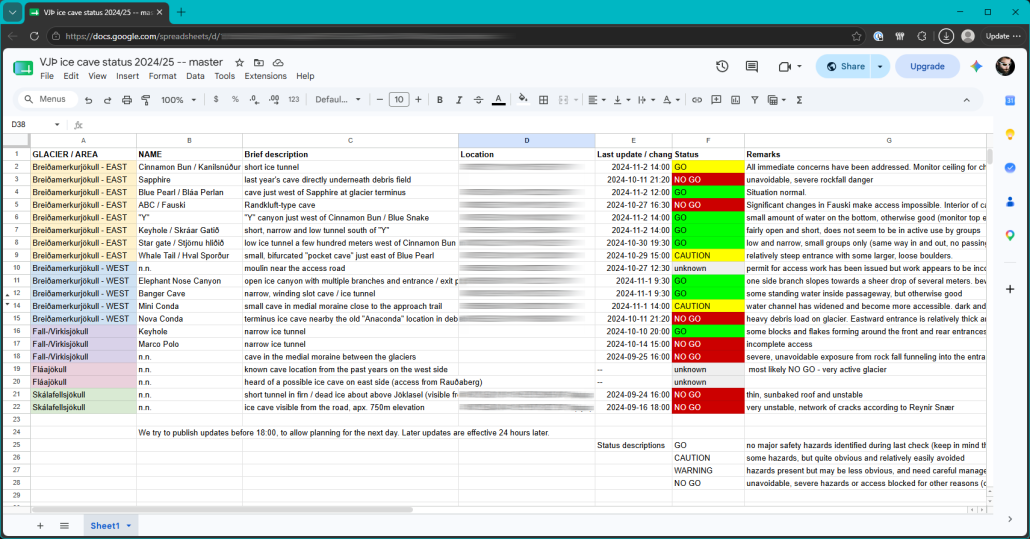
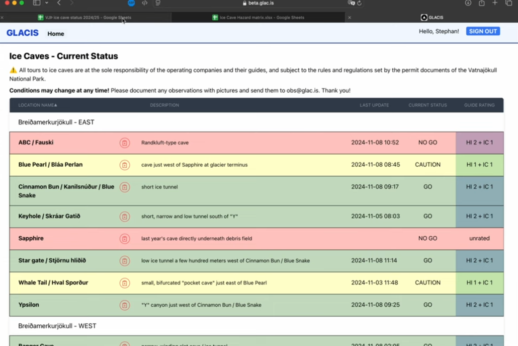
To ensure everybody was informed on current conditions, a simple Google Sheets document was set up that listed the known locations and their status, plus some remarks. It was clunky, error prone, there was no good way to add more in-depth information, and it was definitely not a permanent solution.
Still, it was a start. We began to have a shared view of the situation.
The initial Google Sheets master document
GLACIS 1.0
From these early steps, I started to also have a better understanding of what information might be useful to share between operators. And, most importantly, I thought it would be very useful to see how conditions would evolve over time – is a location slowly but surely deteriorating to the point of being permanently closed, or is the current status a temporary issue that can be resolved?
Fortunately, this is not the first time I have been in this situation. Before moving to Iceland, I have worked on a multitude of projects in the geospatial and information sharing sector – most notably one that was a prototype for shared public-private situational awareness and preparedness for critical infrastructure. So I had a good idea where to start.
It took a few weeks to get an early prototype off the ground, but by mid November we could replace the Google Sheet with a proper website. This first iteration was more of a proof of concept and would need a major overhaul at a later date, but it gave me the flexibility to experiment with the overall structure and data management.
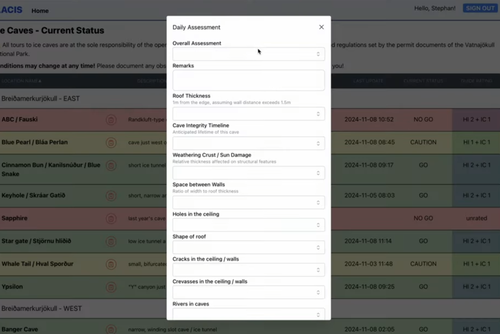
An early version of GLACIS – not so different on the front page
Most importantly, it now allowed all registered users to begin entering their own observations, and review them against all other assessments that had previously been entered. We had gone from a one-way information flow to a true shared knowledge space.
Importantly, on GLACIS all users can add their own assessments and observations.
I had many more ideas about where to go from here, but the system was immediately adopted with such enthusiasm that I was very reluctant to make any further changes during the ongoing ice cave season. Further improvements would need to wait until the following summer, but one thing was clear: GLACIS had already proven itself to be useful.
Better Information
This proved to me that there was a clear pathway forward when it came to collaborative information sharing and shared situational awareness, but two other questions remained open: how can we ensure good decision making takes place, objective and independent of commerical pressures, and which additional information could Fagráð provide to assist in the process?
Weather Stations
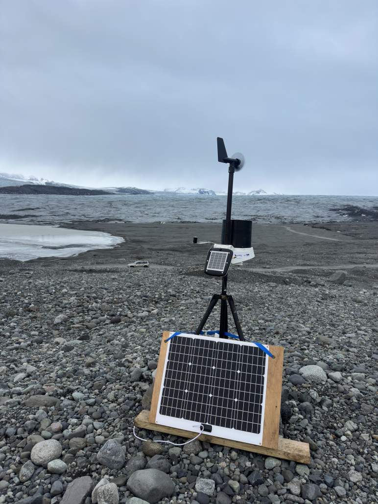
One of the easiest and most obvious tools would be better, localized weather data. We started with a weather station in Þröng on the eastern periphery of Breiðamerkurjökull, which was a good proving ground close to multiple popular locations in the 2024/2025 winter. It worked rather well, and eventually further weather stations on Falljökull, at Jökulsárlón, and the west side of Breiðamerkurjökull. Unfortunately after a year of reliable operations, we have been plagued by outages and technical failures in the past winter, but I am hopefull we will be able to get those resolved over the coming weeks and months.
Setting up the weather station on the west side of Breiðamerkurjökull
Another critical point was a recurring theme of discussions about the thickness of the roof in a particular ice cave. Due to the complexity of this location it was not easy to determine this with certainty just by observation, so I began to look into other options.
Maybe ground-penetrating radar might work? I spoke to a number of geophysicists, and they basically told me that it was not going to provide the information we were looking for. Their suggestion was fairly simple: just drill a hole! That, of course, would have not been very popular and also not always feasible. But maybe there would be other options?
3D Scanning
I had previously worked both with photogrammetry and LIDAR based data acquisition, and knew it was going to be tricky to get high quality photogrammetry in an environment that was full of reflections and transparency. But I was somewhat hopeful with LIDAR. So in early 2025, I went ahead and arranged for rental high-end LIDAR scanners (both a Leica RTC360, and the much more compact and lightweight BLK360) to make some trial scans.
The quality of those scans was remarkably good – the highly transparent ice surfaces also caused quite a bit of noise which made alignment of the individual scan positions somewhat problematic, but we finally were able to develop a full understanding of even the most complex ice caves and their exact situation underneath a complex surface topography.
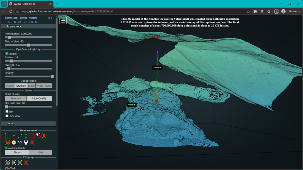
Measuring the ice thickness beween the roof of the cave and the surface ice (Sparkle ice cave, March 2025).
Initial processing and handling of the laser scan data required a very powerful computer, but the finished and optimized data sets are in a format that can be progressively loaded and therefore even viewed on the web – even though they still require a rather stunning amount of storage space (hence why I am hosting them on AWS S3 storage). Here is a link to the viewer shown above:
Over time I got the process dialed in, but with about 30-60 individual scans to be set up, captured, and eventually combined to a complete three-dimensional model of an average sized ice cave, the process will never be efficient enough to provide answers in “real time”. 36 to 48 hours are more realistic, which is certainly fast enough to track slower and progressive changes – and those are really the ones I was most interested in because they occur at a rate that is not easily perceived, but still relevant.
Taking the leap
These scans worked so well that prior to the 2025/26 season I decided to invest in a scanner myself. This was a massive investment, but renting is quite expensive as well and was not going to be a viable solution when it comes to repeated captures at short notice. And it is those repeat measurements are where things are getting really interesting – not only do we now have a static snapshot of a cave structure, but by carefully aligning the models taken at different times we can begin to see the changes.
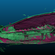
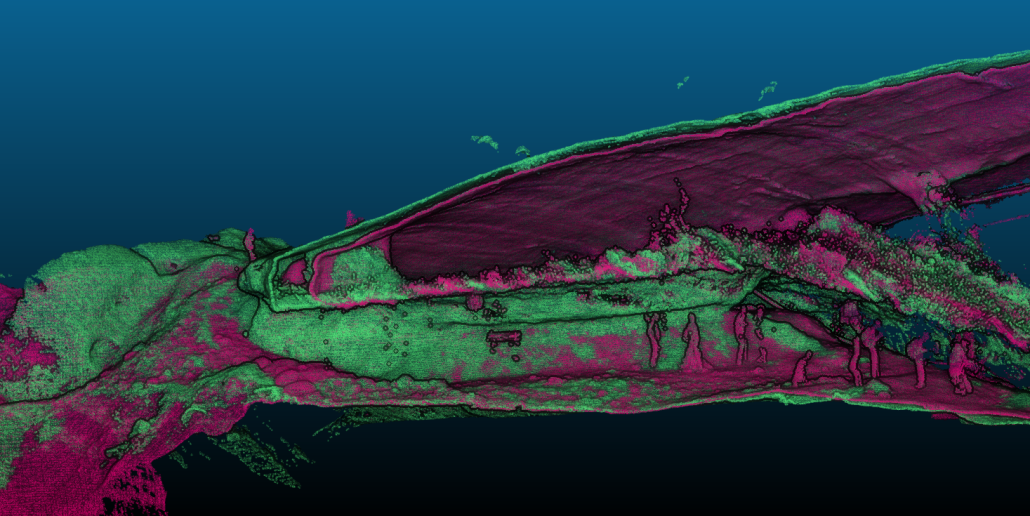
Comparison of two scans, taken about a month apart. It is quite evident how the later (purple) scan has melted away at the edge on the left and and down from the surface, whereas the underside of the cave has remained unchanged and also does not show signs of deformationin relation to the (rocky) ground floor.
These alignments are tricky because in many situations there are no fixed reference points: every aspect of the cave may move or change between captures. There are ways in which this might be resolved, but interpreting the result is always going to take time and experience.
In any case, interactive 3D models are great for these explorations because they give the user a tremendous amount of possibilities. But when trying to answer specific questions and communicate them, it often makes sense to go one step further and condense the data into a more concrete form. For example, how is the thickness of the ice distributed across the roof?
This, too can be answered with a bit of processing.
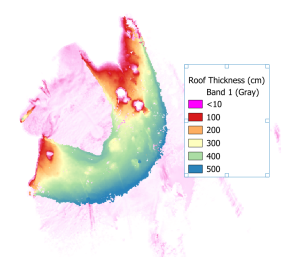
Roof thickness map of the “ABCD South” cave, winter 2025/26, showing how the thickness of the roof was generally 3-5 meters with cleary visible variation in some areas and around the openings on the left and top side of the image. The larger, light pink areas are solid glacier.
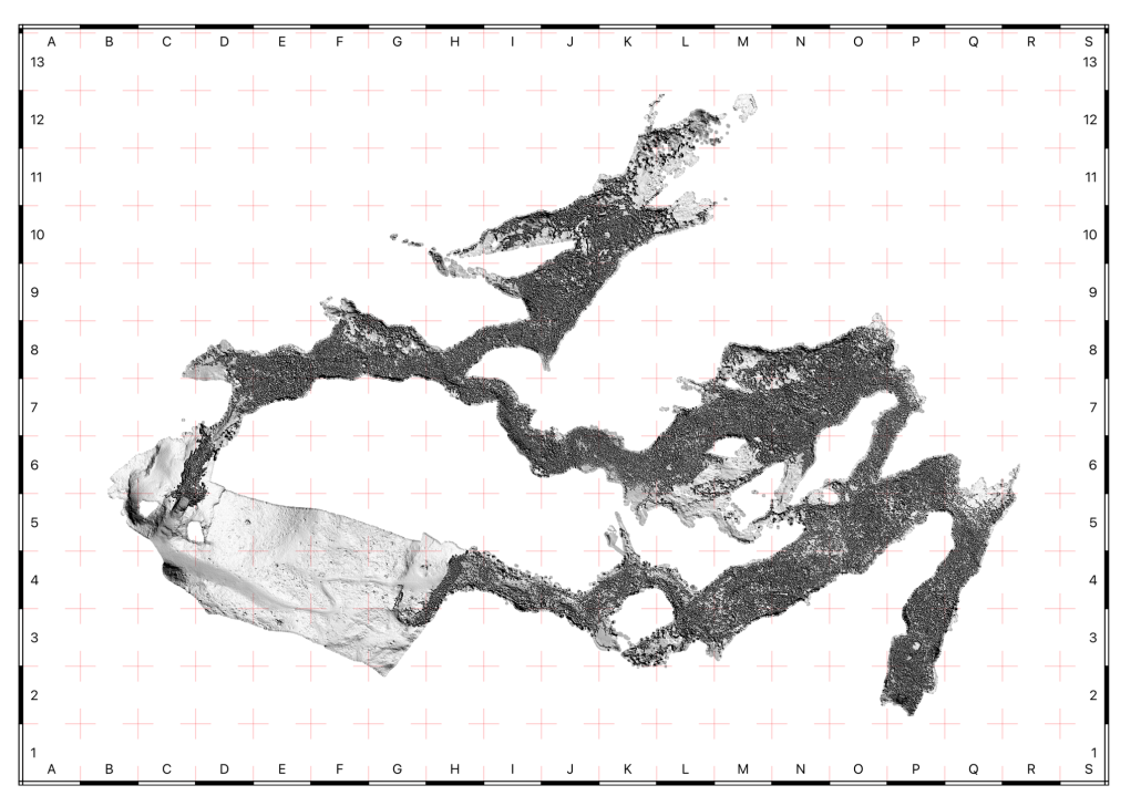
Mapping ice caves at a larger scale also facilitates communication about particular sections of the location. Most caves we deal with are relatively small and straightforward to discuss, but there can sometimes be a complex situation where having a reference grid can be helpful. The best example was the “Sparkle” ice cave of the 2024/25 winter, which was quite remarkable in extent and number of side passages.
Overview map of the Sparkle ice cave (2024/25) with its multiple passageways and chambers. This map was derived from a 3D model consisting of more than 60 individual scan locations. The grid overlay made it possible to accurately point out specific locations within this structure.
Photogrammetry
Talking about mapping, this also was a great topic of interest on the glacier more generally. For larger surface areas, a terrestrial laser scanner is not really the right tool; this is where aerial photogrammetry shines. I first had the idea of opportunistic glacier mapping in 2018, primarily to see how far one can get with nothing but a consumer-level drone in the backpack and a bit of time, for example while customers were having a lunch break.
The “Treasure Island” area with its twin ice caves in the winter 2017/18, from the original opportunistic mapping project.
Our expectations have evolved in the meantime, and especially when it comes to aligning those large-area photogrammetry captures with terrestrial LIDAR scans demands on precision and repeatability are quite a bit higher – although not insurmountable. But even with just high quality photogrammetry we can deliver some high value information, and easily surpass commercially available satellite imagery by one or two orders of magnitude. Even early attempts such as the image above achieved 5cm orthoimage resolutions, whereas commercially available “super resolution” imagery is only 2 or 3 meters.
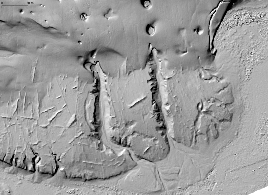
And, while orthophotos are nice, but they don’t always reveal the shape and structure of the terrain. This is where a digital surface model helps, especially if it can be produced at high enough resolution to resolve smaller scale surface details. Because of how the computational process works, the geometric models are usually at lower resolution than the resulting orthoimagery, but not necessarily. In the example of Treasure Island, the DSM is at the same resolution, and at 5cm even smaller features become apparent and the different structure of the glacier and surrounding landscape is clearly apparent.
“Hill shaded” digital terrain model of the twin ice caves in the Treasure Island area, from the 2017/18 winter.
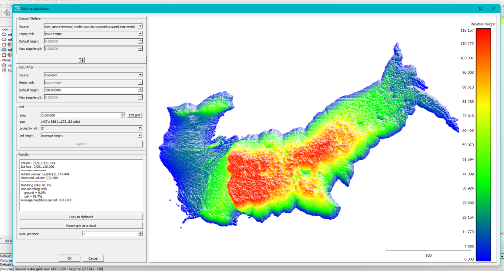
This photogrammetry expertise also came to good use recently when I was able to quickly respond to a Jökuhlaup event in Innri-Veðurárdalur and create a topographic map of the now-empty valley floor. From this data and the high water mark it was possible to estimate the total volume of water discharged in the event. While similar data is available from remote sensing satellites, the resolution achieved by photogrammetry is several orders of magnitude better.
Volume estimate from a photogrammetric capture of the Innri-Veðurárdalur valley floor below the high water mark.
GLACIS 2.0 and the 2025/26 Season
Over the summer of 2025, I took the lessons learned from the prototype portal and started to work on what ended up being “version 2.0” but really was the first proper version of the system. The most notable changes were a map display of the various locations, the option to upload photos and associate them with all these places, and the possibilty for users to add locations themselves. I also experimented with supporting the entry of time slots where companies might be able to enter the anticipated tour schedules (which might have helped with avoiding times of heavy “rush hour” traffic), but those ended up not being used at all.
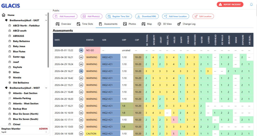
Assessments overview of one location in the 2025/26 season, in the second iteration of GLACIS.
Assessment Groups and Fagráð
The past winter also saw some changes to Fagráð and the assessment groups.
The accident in 2024 of course severely disrupted the inherent trust the Vatnajökull National Park – and other authorities – were ready to put into the judgment of tour operators, and it would take some time to rebuild this. Consequently, Fagráð took a quite active position in many decisions in the 2024/25 season, but one of the main topics of discussion over the past years had often been how involved it should be with the daily operations and assessments of individual locations in the long term. Having a relatively small group creates a multitude of issues:
The limited manpower does not not scale well to even a moderate number of locations, and consequently negatively impacts the frequency and quality of any assessments that can be made by members of Fagráð alone.
Since members of Fagráð are, by definition, also employees or possibly owners of companies operating tours, any actions or decisions made solely by Fagráð may be perceived as being biased towards their operational preferences.
There are over two dozen tour operators in the Vatnajökull National Park, many with a tremendous amount of experience and excellent track record. Disregarding their expertise in assessing locations is, simply said, stupid.
The final decision and responsibility must always remain with the guides in the field. Not incorporating them as much as possible in the assessment process sends the wrong signal of ‘those decisions are being made for you’.
For the 2025/26 season, we tried to restructure the way assessments are made. Instead of having mostly online meetings with the occasional on-site conversations like we did in the previous winter, I suggested focusing as much as possible on on-location assessment group meetings. We arrived at having those meetings every other week, on separate mornings for each of the general areas (east and west side of Breiðamerkurjökull, and Falljökull) where companies would attend those they actually operated in. Members of Fagráð (usually me, and often one or two additional members) would also attend these meetings and provide additional input, but the goal was always to make the final assessment decisions as a group.
A monthly “general” assessment group meeting was held online to discuss things that were of importance to everybody, and of course additional meetings (both on location and online) would be scheduled whenever deemed necessary.
In my opinion those meetings were a great improvement, both with getting more experience and opinions into the assessment process (which also made this more transparent to everybody) and encouraging companies to be active in their role. But there was some friction with this approach as well, for example the timing of those meetings was difficult for owner-operators who could not participate due to their own tour schedules (but could more easily make room for an onlin meeting in the later afternoon or evening), and the communication of meeting outcomes could certainly be improved as well.
Going into 2026
All of these processes provided a good foundation of data, but opened up a new question: how to share the various data I am producing, in a way that makes it most useful to the guiding community? I also observed that people were taking screenshots and drawing annotations on them, to point out various features. That felt clunky and brittle, and needed a better solution.
From a technical perspective, it was time to revisit GLACIS. Work on the next generation of the portal started almost immediately after it went online originally, but it was a major effort and required careful planning to ensure it is the right foundation to build upon. I have many ideas about future improvements, but it made most sense to keep the first release of this rewrite within a relatively narrow scope.
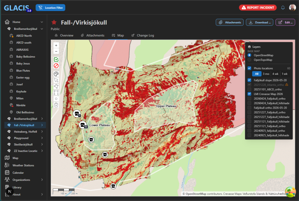
GLACIS 3.0 will be a complete rewrite to the platform, including ways to filter the growing number of locations, drawing annotations, showing photo locations on map, streaming realtime weather data, and much more.
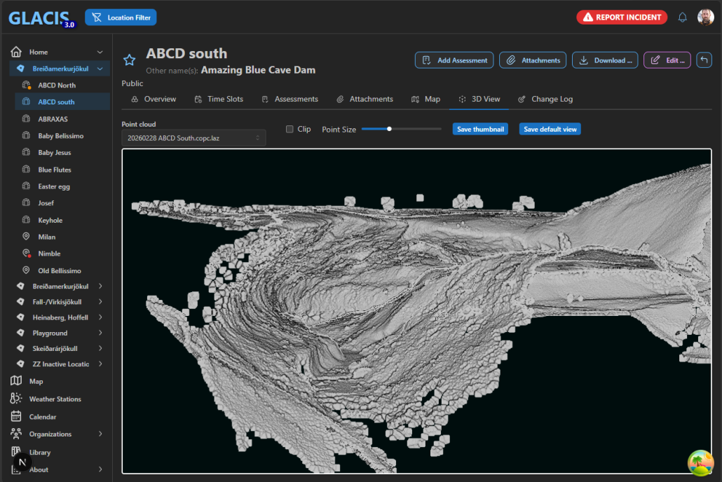
The platform will also provide deeper integration for the 3D data I have been collecting, including a more functional 3D viewer, the ability to view multiple data sets for a single location (and see its changes over time), manage viewpoints, and more.
LIDAR and photogrammetric scans are getting a full integration into the platform, supporting data sets with hundreds of millions of points.
Summer Assessment Groups
I expect the work of Fagráð and the Assessment Groups will continue to evolve at a similar pace – it feels like we are beginning to hit a groove and on Falljökull there has been strong interest from the companies to keep the on-site meetings going over the summer months. This shows to me that they see a tangible benefit to these conversations. There is not always a specific and urgent agenda, but there is always an exchange of observations, ideas and concerns.
Those meetings are completely voluntary, and I am not sure whether they would make as much sense in all areas, but it is clear to me that it is extremely valuable to build opportunities for guides to get together in a way that they find useful. Because this is how we build a strong community that transcends company boundaries.
Course Work and Training
Earlier this summer I created a questionnaire that was sent out to the 300+ guides who have attended the AIMG ice cave course in the past. Similar questionnaires have been sent out directly after the conclusion of the courses, but I wanted to gather feedback that was more focused on their view after having worked for at least one season after the course: did anything come up during their guide work that the course had not addressed well enough? Were there any points that turned out to be mostly irrelevant?
This feedback will be the foundation for revising the ice cave course over the summer. While I believe the current curriculum is already a good primer, the survey certainly provides a wealth of valuable information about how the course can be made more useful to the guides and give them the best possible tools for their work.
A cynic’s work is never done
In summary, I believe that one should never be fully satisfied with the status quo, but constantly strive for improvement. Much is left to be done, but looking back at the past two years I would like to think that the time was well used.
I am incredibly grateful for all the support and trust I have received from everybody involved, including the National Park and members of Fagráð, but especially from all the companies. Without them, none of this would have been possible.
https://www.stepman.is/wp-content/uploads/2026/06/666362420_929051183242730_4818559643774545369_n.png7351467stephttps://www.stepman.is/wp-content/uploads/2023/10/WP_Logo_Black.pngstep2026-07-04 07:11:322026-07-04 20:44:48700 Days
I was part of an ICE-SAR response to an incident on Falljökull last Wednesday. As always when something happens in a professional guiding context, it is worth to summarize observations and look for lessons to be learned. What was missed, or went wrong, for this accident to occur? Where can the guide community improve to hopefully prevent it in the future?
A redacted version, with personally identifiable information removed, can be found here.
As a consequence of the accident in late August, I decided to include an explicit section on overhead hazards in my safety plan. As always, it is public and you can check it out here (the entry in the menu above will always refer to the most current version; this one is a permanent link to this particular revision, 4.1).
UPDATE Sept 20: The National Park sent out a statement to all tour operators today about the expected qualifications of guides making hazard assessments, and I went ahead and integrated those into the safety plan. The new, revised version (4.1.1) is here and now also in the top level menu.
https://www.stepman.is/wp-content/uploads/2023/10/WP_Logo_Black.png00stephttps://www.stepman.is/wp-content/uploads/2023/10/WP_Logo_Black.pngstep2024-09-17 17:53:452024-09-20 21:20:56Safety Plan Update – Version 4.1.1
I have received an incredible amount of very positive feedback about my recent essay, and it motivated me to address some of the questions that came up both in direct response to it and in other discussions.
This article is intended primarily for visitors who are concerned about various planned activities, and deals specifically with the situation in Iceland. A discussion detailed enough to satisfy glaciologists and outdoor professionals is clearly outside the scope of a simple blog post!
What makes ice cave tours different from other glacier excursions, such as glacier hikes or ice climbing? Or are they all equally dangerous?
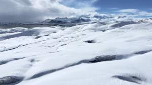
Summer ice. The weathering crust is soft and easily broken into smaller fragments.
The answer, as one would expect, is complicated and depends on many factors. One could (and possibly should!) write an entire book on the subject, but we can certainly examine some general aspects. Here I will focus on the glacier itself, and particularly on the areas most commonly visited for tourism activities, which are snow free in the summer months (the ablation zone).
Let us begin by examining how a glacier evolves throughout the seasons. In summer, the glacier is exposed to near 24 hour daylight, warm temperatures and rainfall. This deteriorates the upper layers of the glacier in a way commonly called sunbaking – essentially each of the individual crystals melt along their boundaries until they entirely lose adhesion and become what is perhaps best described as a brittle set of loose puzzle pieces. Importantly, this does not only happen at the surface, but because the sunlight penetrates into the ice also progressively occurs into greater depths forming a layer that is called the weathering crust. This means that as this process continues throughout the summer, the glacier not only melts at the surface but also deteriorates internally, while at the same time loose fragments on the surface get entirely eroded away or dislodged by gravity, surface water, or other effects. Surface water also continually seeps into surface defects and can further affect the ice in ways not easily observed from the outside.
There are noteworthy exceptions, of course. For example, any glacier that is covered with substantial amounts of debris (such as volcanic ash in the case of Kötlujökull) may be protected from much of this effect and exhibit slower rates of change.
Winter ice. Notice the glassy reflection and how little the crampons penetrate into the ice.
In winter, the glacier is either protected by snow cover (which entirely stops erosion) or is exposed to very little sunlight – this causes the weathering of the glacier in the winter months to primarily occur at the surface level, leading to the highly polished, smooth and glass hard winter ice.
With these basic processes in mind, we can now examine their consequences for various types of excursions on the glacier.
Surface Activities
Snow cover beginning to obscure smaller features
Consequently, if a glacier activity remains on the surface of the ice (such as a glacier hike), the loose and relatively soft summer ice is in many ways preferable. There is great traction with crampons, and the roughness of the sun baked crystals means that a person that fell down would just remain put in most normal terrain – although they may cut their hands on the sharp edges if not wearing gloves. Any degradation of the ice into greater depths is not a concern since we will generally walk on top of many meters of ice that is at no risk of collapse under our weight, and it is still very strong under the negligible compression of our body weight. Loose ice can be easily removed to access solid, blue ice underneath for building reliable climbing anchors.
This view point clearly requires adequate fall protection.
In contrast, winter ice can be so hard that especially lightweight clients will have a difficult time finding good purchase with their crampons. The exposed ice is much harder, and even if the crampons have been sharpened to a sharp point do not penetrate very well. A stumble may quickly lead to a slide that is very difficult to recover from – so even otherwise very benign terrain may need to be protected.
A light snow cover greatly diminishes this risk once it has bound with the ice underneath. However, a more substantial layer of snow causes traveling over the glacier to become more hazardous, because windswept snow can easily obscure any dangerous spots in the surface. Larger moulins are likely to remain somewhat visible, but even a misstep into a smaller void underneath the snow could easily result in a sprained ankle, knee injury or other harm.
To protect from these fall hazards, good route choice and the use of fixed or temporary ropes are generally sufficient and easily managed.
Overhead Hazards
Once we are exposed to any overhead hazards, the picture changes. In the summer, we routinely see smaller fragments coming loose under their own weight and harmlessly tumbling down surprisingly moderate slopes, and if the structure becomes steeper the chances of larger pieces breaking off increases dramatically. In particular, if a feature is free standing (such as an isolated wall) the sun baking may occur from multiple directions until there is no core with good integrity left.
Some potential overhead hazards are easy to identify, such as this structurally unsound roof. Others may be much more difficult to spot.
We also need to keep in mind that while ice is very strong in compression, even in its compact form it is quite weak in tension, and any ice affected by sunbaking will exhibit dramatically lower tensile strength yet! We must therefore rely on any overhead features to be well supported on both sides, having a good, self supporting shape, and suitable thickness.
Whether we encounter those overhead hazards on a normal glacier hike (maybe walking a bit into an accessible crevasse, like routinely done on Falljökull, or into a moulin as it has been popular on Breiðamerkurjökull), because we are suspended from a rope and climbing up a vertical wall, or going into an ice cave does not necessarily change the character of the hazard.
What does change however is how long we are exposed to the risk, and if that particular location is an essential component of the tour program or can be easily avoided.
On a glacier hike the guide can always choose to not approach any vertical or overhanging terrain at all, or if it cannot be avoided mitigate the risk by limiting the duration of the exposure (very much in the same way one would pass through a potential rockfall area without stopping).
For ice climbing, we must indeed be in sufficiently steep terrain that allows the client to learn good ice climbing technique and gives a good experience – but since essentially all commercial ice climbing tours are top rope scenarios, loose material can be easily managed from above before the client proceeds to climb.
Therefore, for both glacier hikes and ice climbing, approaching and inspecting the overhead feature closely is generally possible without much additional effort, and allows for good and timely judgment of its condition.
With ice caves, the whole premise of the tour is to spend the majority of the duration exploring areas underneath the surface, and thus the overhead hazard is continually present or at least cannot be avoided when entering and leaving the area. Space is often limited and there is not enough room to avoid prolonged exposure overhead hazards. In a sufficiently large cave, the inner sections are often covered with sufficiently thick and homogenous ice that a collapse is unlikely – although there have been exceptions with pieces of the otherwise stable roof flaking off, icicles forming overhead, embedded rocks threatening to melt loose, etc. Furthermore, inspecting many of those overhead features in detail is generally more difficult, if at all possible, more time consuming, usually requires leaving the group temporarily unattended, and may therefore be limited to infrequent checks. Those may be sufficient in the winter months, when the rate of change is generally relatively slow, but becomes extremely problematic during the summer.
Other Risks
Of course, the integrity of the ice is not our only concern on glacier excursions. Common to all activities is that there is generally no easily accessible shelter from severe weather (except in larger ice caves, which can remain surprisingly comfortable even if there is a raging snow storm on the outside).
Also common to all glacier activities is that most clients are unfamiliar with the use of crampons, and the risk of self injury or stumbling certainly needs to be considered. Ice axes and ice climbing tools further increase this risk, especially when used or carried incorrectly.
Particular to ice climbing, protective eyewear is important to prevent injury from ice spray and clients with poor technique are at a considerable risk of hitting their knuckles when placing the ice tools. Bystanders, including the guide if belaying from below, are at risk of being hit by ice dislodged by the climber. And clearly the proper use of all safety equipment and good belaying technique are critical to ensure a potential fall of the client is caught safely. Warm temperatures and sunbaking require the rope anchors to be carefully planning and constructed, protected from unnecessary deterioration, and may need to be checked frequently. Ice screws have high thermal conductivity and may melt the ice surrounding them, becoming loose over a relatively short time if ambient temperatures are high. This is less of a concern in the winter months.
Ice caves are generally formed by subglacial water flows or geothermal activity. Those water flows generally subside in the winter when both meltwater and rain are diminished, but especially during warm spells and spring can increase dramatically. Water held back by the glacier in subglacial or marginal lakes may spontaneously drain as a jökulhlaup that could reach into ice caves or the proglacial area around the cave. A warm spell and rain falling onto snow cover can release substantial slush flows that might drain into exposed areas such as moulins. Geothermally formed ice caves, if poorly ventilated, can accumulate high levels of toxic gases, or reduce oxygen concentration with inert gases to dangerous levels.
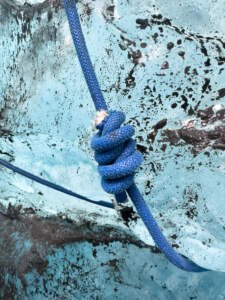
Some knots can’t be trusted to hold.
Finally, sloppy or poorly maintained safety precautions can substantially increase risks. A rope, handrail or bridge will be trusted by customers to be reliable and trustworthy. On a warm, rainy day it may take only a few hours until an ice screw melts loose enough to be dislodged with minimal force, and while V threads generally last longer they too eventually melt out. In both cases whoever was pulling on the rope to keep their balance will have a very nasty surprise. Poorly tied knows may come undone with catastrophic results. Ropes left to freeze onto the ice may snap loose once a client pulls on it, throwing them off balance. In all of these cases, it might have been safer if there were no rope in place at all!
Putting it all together
In summary, one could very generally say that –
Glacier hikes are safest in the summer, and some additional risks must be managed in the winter months.
Ice climbing is generally somewhat more dangerous due to the use of additional, very sharp tools, necessary exposure to heights and general character of the activity. While overall easier in the summer months, care must be taken to build reliable anchor structures and reduce the risk from falling debris to the climber and any bystanders.
Ice caves are safest in the winter, when the cold temperatures and limited sunlight allow the ice to remain relatively stable. There is a very high risk both in the spring when snowmelt and slush flows must be expected, and later in the summer once the deterioration through sunbaking penetrates any overhead ice structures to dangerous levels. The most dramatic changes haven often been observed from mid August until early October.
While both glacier hikes and ice climbing occur in environments that are more easily managed, and there generally is a much larger range of options to choose from, ice caves are dramatically more limited in number and allow fewer alternatives for risk mitigation or avoidance.
There have certainly been years where exceptional conditions allowed ice caves to be visited earlier than normal, later into the spring, or perhaps even in mid summer, but we must be careful to ensure that such an exception does not continually become the new norm due to outside pressure or expectations.
Ultimately, glaciers are a rapidly changeable environment. Safety plans, regular site evaluations and standard practices are all valuable tools but cannot replace a well trained guide who is able to competently assess the situation in the moment, and also has the authority to make possibly drastic decisions about any tour. This requires training, experience, and a supportive work environment.
This unpredictability is why almost all guide companies will not generally offer ice cave tours outside of a time frame where experience over the past decades has shown that visiting them can be performed in a safe fashion, and even within the winter months sometimes must be canceled.
https://www.stepman.is/wp-content/uploads/2023/09/dsc9938.jpg11252000stephttps://www.stepman.is/wp-content/uploads/2023/10/WP_Logo_Black.pngstep2024-09-01 12:28:002024-09-01 22:47:41Safety on Glacier Excursions
The tragic collapse of an ice cave left us mourning the loss of a life, a family torn apart and many lives irrevocably changed. I have just returned from two days on the site of the incident, and staring at the computer screen I keep asking myself the same question again and again: How on earth could this happen?
This post is my attempt at answering this question, because only if we fully understand what went wrong can we hope to prevent it from happening again in the future.
My knowledge of what exactly occurred and even which guides or companies are involved is incomplete, so we must satisfy ourselves with exploring all possible options, not all of which may actually apply – but we will see that there is somewhat of a golden thread through this discussion.
I am not even going to name the company involved, because this is a systemic problem that has pervaded the entire industry. The first symptoms have been showing up for years, and critical voices were constantly ignored. So while clearly one company took things too far, this does not absolve everybody else from also taking a very long, hard look at our own practices, and trying to see where we can do better.
The Guide
First of all, it must be abundantly clear that the final decision on safety aspects of any tour must always be made by the guide who is on site. They are the last defense against any other safety measures that failed or were overlooked.
This requires training, experience, and the right mindset. A young and inexperienced guide, possibly with minimal training, is much less likely to have the confidence to “disappoint” their customer by turning away from something that maybe their gut instinct tells them is not looking quite right… but yesterday everything also went well so why should something happen today?
There is a very good reason why any formal guide training is usually in stages, where guides become increasingly independent – going from trainee (guiding under direct supervision by a more experienced guide), to apprentice (guiding under indirect supervision), and then finally to full guide (where they have accumulated enough experience to be able to make the correct decisions 99% of the time, and know how to safeguard against not catching the remaining 1% before it is too late).
The tour itself may be very low key – after all, most glacier experiences are at a level that is entirely suitable for first-time visitors – and not require any particular skills from the clients on a day-to-day basis. In many ways it is reminiscent of the job that flight attendants have – if all goes well it looks like they are just there to serve in-flight refreshments, but they are exceptionally well trained to deal with a variety of emergency scenarios that are incredibly unlikely.
All of this also requires the right company culture, where this process is encouraged and supported, and guides know their superiors will have their backs — even when they turn back and need to refund large sums of money to disappointed customers.
The Guide Company / Tour Operator
The company operating the tour, as a whole, is perhaps the central figure in this picture. They construct the tours, determine group size, locations, time constraints, and all other aspects of the operation.
Importantly, they determine which qualifications the guides have they will send out on each tour, under which constraints those guides operate, and most importantly also establish a certain company culture. In some instances there may be a construct of subcontractors, which is usually little more than false self-employment, and I think we can safely ignore this fact and just consider those as a single organization.
A guide that is sent out with minimal qualification and training, as pointed out above, will not have the necessary tools to make good and safe decisions, and will need to rely on instructions from their superiors – who may not be on site, and may be using outdated information. One of the critical aspects of late summer is how rapidly glaciers change, especially in August and September when they have been baked by sunlight and warm temperatures, and infrequent reviews are entirely inadequate. It would have been the company’s responsibility to ensure safety checks are performed sufficiently often, which in this time of the year may indeed be every single day.
Even with proper training, a company that encourages a “laissez-faire” approach to safety may weaken the guide’s perception of risk to the point that their own threshold for what is acceptable changes as well (“all the other guides still go, so it must be okay and my own perception must be off“).
One illustrating detail in this particular case is that it turns out we were looking for two additional casualties that did not actually exist – the total number of participants on the tour had been miscounted. In any mass casualty event, tracking and accounting for every single person involved is one of the most critical aspects. It is therefore quite surprising that in the moment when two persons were not accounted for, the numbers were not immediately verified. One would think that this would have been easy enough through the online booking systems even the smallest companies use nowadays, where people are “checked in” as they arrive, or at least tracking credit card receipts if there was a suspicion people had “walked in” without prior arrangements). Obviously each guide must have known how many passengers they had in their vehicles, or the clients themselves could have been interviewed to find out the seating arrangements and deduce any missing individuals, but humans are notoriously unreliable and possibly disoriented in the aftermath of such events.
In any case, the fact that the reported and actual numbers neither matched nor were corrected quickly does lead one to believe that the processes for tracking and accounting for customers on these tours were inadequate, or not followed, which may be symptomatic of a rather lax company culture in general (and thus possibly also towards safety).
Furthermore, a guide who is under tremendous pressure from their superiors may feel obligated to proceed with a tour against their better judgment, for fear of losing their job or prestige within the company. This problem is of course even more amplified if the guides are young and/or inexperienced, which makes it even more difficult to push back against one’s superiors and cancel the tour anyway.
The Online Travel Agency (OTA)
Finally, we should not forget to consider why a guide company feels the need to compel their guides to run certain excursions. And in my opinion, online travel agencies / marketplaces play a substantial role here. They are often the customer facing entity, during the booking process, and for many clients indeed indistinguishable from the actual operators.
Almost all companies also operate their own direct booking websites, but it is safe to say that for most tour operators the vast majority of clients will come through the major OTAs (Arctic Adventures, Guide To Iceland, Tröll, Viator, etc.).
As such, the OTA can potentially create a tremendous amount of pressure, especially if they are effectively the sole source of customers for a given tour operator – and just like as a guide, saying no to one’s superiors is difficult for fear of being replaced by another, more willing guide, a tour operator that declines to offer a certain activity may end up being replaced by another supplier. This, coupled with the misguided assumption that if other tour operators are willing to arrange a certain activity, it must be possible to do it safely, spirals into a continued decline of boundaries and possibly safety standards.
It takes very strong leadership as a company to push back against this market pressure, but I would also fault the OTA for creating this demand in the first place. They, of course, may be willing to sell anything since for them any activity results in a neat commission and basically no operational risk, and if they can offer something that the other OTA’s don’t have (such as a summer ice cave tour), they will really want to have that cake. And therefore they will prod the tour operators towards extending their season further and further until it becomes year round.
At the same time, if the OTA would have done their due diligence and evaluated the possible risks involved with each of the activities they offer, they might have come to the conclusion that such a tour cannot be operated safely, and thus never include it in their program. As such, they too failed to defend and protect their customers against an activity that for many years was well known to be too dangerous to consider but crept into the common marketplace in very recent years.
The Customer
And where does this leave the customer?
It would be easy to say that each customer is ultimately also responsible for their own safety, and if they would do their due diligence they should be aware of the risks involved and consciously accept them when booking.
That, in my opinion, is mostly incorrect. Of course we all are in the end responsible for our own wellbeing, but especially when it comes to guided tours we book those precisely because we are venturing into an unknown environment, and trust a trained professional to make it a safe and enjoyable experience.
Very few clients of glacier hikes or ice cave tours have the necessary knowledge, training or experience to accurately evaluate what constitutes a safe or unsafe environment, and even less so from a brief description on a website in a country that they may have never visited before (and thus also cannot really judge for example how the local climate factors in).
A certain amount of perceived risk, even if it does not relate to any objective danger, may even a welcome part of the experience of being on an adventure. But it is of course unacceptable to expose customers, oneself, or third parties to any objective dangers, perceived or unseen by customers.
And thus, we have come full circle.
The guide failed their customers because they did not perceive, address, or avoid a severe overhead hazard they were exposing their clients to during the tour.
The tour operator failed their customers because they were willing to arrange an activity that carries a very high risk in a highly volatile environment, without giving their guide the necessary tools, training, and support to mitigate the risks involved.
The online travel agency failed their customers because they were willing to sell those tours, marketing them as an entirely safe adventure.
But wait, there is more. The National Park, as the overseeing agency of all commercial operations within its territory, failed its visitors because they did not sufficiently monitor the commercial activities, perceive the increasing risks associated with those activities, or take suitable action.
Any one of those could have avoided the tragedy with suitable actions. None did. Out of complacency, financial motivation, external pressure, or ignorance.
What now?
How can we ensure this never happens again?
Some may point to quality management programs like VAKINN, but I very much doubt that is an actual solution. I have seen too many actions of guides from certified companies that are in clear violation of these standards. Paper, after all, is very patient.
Neither would a blanket ban on “summer ice cave tours” per se work. A sufficiently motivated company could easily just label them as glacier hikes of some sort where most of the time happens to be spent inside one of those structures. When ice climbing or visiting moulins, one could easily end up in a place that is quite similar in structure to the incident site but objectively safe and possibly the most memorable moment of the tour.
The only solution, in my opinion, is a thorough cultural shift that pervades all layers of the tourism industry.
We must put our customers’ safety at the front, throughout every decision we make. From OTAs ensuring customers come well informed about the right clothing and a good concept of what the tour might be like or how it might need to change, to tour operators and guides providing them with the right equipment and instructions. Guides having full authority over cancellations or changes as well as the training and experience they will need to make those decisions. Encouraging a company culture that prioritizes safety over all other aspects of the tour (including whether it takes place at all or not), having online travel agencies that decline to carry overly risky activities and explain to their potential customers why some tours may be seasonal, and having a National Park where the rangers have the training, authority, and legal framework to put a stop on commercial activities that are deemed unsafe. I could also envision an expert panel that reviews these activities, perhaps by anonymously booking them as seemingly regular guests.
Is all of this likely to happen? Probably not.
But one can dream, and one can set an example and hope others will follow.
Which is why write incident reports whenever I feel there is an important lesson to be learned. Why my safety plan is public, for everybody to read and hold me accountable for. Why I am organizing training days that are free of charge for other guides. And why in this text I am desperately grasping at ways to extract some sense of meaning from an event that should never have happened.
Because I want to live in a world where nature in all her beauty is enjoyable, exciting, an adventure — but first, and above all, safe.
https://www.stepman.is/wp-content/uploads/2024/08/IMG_6261.jpeg19202560stephttps://www.stepman.is/wp-content/uploads/2023/10/WP_Logo_Black.pngstep2024-08-27 08:11:172024-08-28 18:07:17Thoughts on recent events
It was time for my annual review of our safety plan — no major changes, but it is good to go through everything that we encountered over the past year and see if anything could be done to improve the situation.
Maybe the biggest change that has come from this was the observation that many clients could benefit from being able to rent boots – especially when ice climbing, where the rigidity of a full-blown mountaineering boot vs. softness of normal hiking footwear can make or break a great climbing experience. So I just ordered a number of B2-class boots (rigid soles, compatible with stiff, lever-lock crampons).
Otherwise, most changes were clarifications where I felt like certain sections were a bit unclear, or where experience showed that some additional steps were warranted. But overall, the safety plan has served us well over the past year.
As always our safety plan is of course public. You can find it here.
https://www.stepman.is/wp-content/uploads/2023/10/WP_Logo_Black.png00stephttps://www.stepman.is/wp-content/uploads/2023/10/WP_Logo_Black.pngstep2024-08-20 21:41:242024-09-01 12:28:57Safety Plan Update – V4.0
I’ve changed from using Adobe InDesign for layout to LaTeX. The final output is not so very different, but using TeX will give substantial advantages when it comes to change tracking and comparing revisions (which is really, really helpful when trying to maintain multiple languages and trying to figure out which paragraphs need to be re-translated!).
Otherwise, I have incorporated some feedback from the Vatnajökull National Park during the application process for getting my permit renewed. Nothing earth shattering, but the safety plan is now hopefully a bit more clear about my client profile, weather concerns, and the remoteness about the area I operate in.
There is now a space where I plan to go into more detail about the changes made in each revision and other information that may be important to incorporate, but should be kept separate from the main matter to keep it concise.
https://www.stepman.is/wp-content/uploads/2023/10/WP_Logo_Black.png00stephttps://www.stepman.is/wp-content/uploads/2023/10/WP_Logo_Black.pngstep2023-10-06 20:44:152024-09-01 12:29:13Safety Plan Update – v3.2
Our safety plan is a living document. It is updated whenever we identify aspects that could be improved, and in recent conversations with Tún, our certifying agent for the VAKINN quality standards, we received some valuable feedback that we have immediately begun to incorporate.
https://www.stepman.is/wp-content/uploads/2023/10/WP_Logo_Black.png00stephttps://www.stepman.is/wp-content/uploads/2023/10/WP_Logo_Black.pngstep2022-11-30 21:47:042023-11-03 21:21:37Safety Plan Updates