Glacier Radiology Support
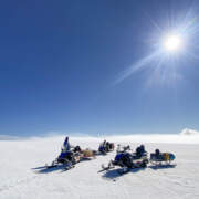
I spent the first few days of September this year on the Vatnajökull ice cap, helping researchers from the Glacier Radiology Group at Stanford University with testing their prototype equipment (most of which will ultimately be used for research in the Antarctic and in Greenland). Overall conditions were amazing except for one storm day that we essentially spent inside our basecamp on Grímsfjall, where the Icelandic Glaciological Society maintains a small research station. I used the time to develop a small tool for importing their radiometry data into 3D software for visualisation – maybe a bit unexpected, but not really for a mountain guide who happens to also have a Ph.D. in computer science!
Driving on the lower parts of Skálafellsjökull was cumbersome, primarily because late summer snow tends to be extremely uneven and progress is slow. Higher up however a recent storm system had smoothed everything out and allowed us to cruise comfortably at good speeds. The flat surface was of course also much better for both the UAV and towed configuration we were testing. We encountered a few crevasses here and there, but they were all easily managed.
⚠️ Mobile device support for the 360° panoramas below is a bit dodgy – I am working on finding a better solution but for now those are best enjoyed on a full-sized computer. Sorry!
Grímsfjall is one of those surreal places that are hard to believe actually exist. And because of the particular local conditions, it also is very often hiding itself in a cover of fairly dense fog. I have been there many times, but rarely enjoyed visibility as good as this time. The views were just amazing. I also created a panorama further out above the caldera lake, and one from Svíahnukur vestry, the western peak of the caldera rim. You can flip through them below.


